Visitor Map for Piwik Web Analytics
 If you’re using Piwik, the open source web analytics tool, then you probably already missed a map visualization of your visitors location, which is a standard feature of all major web analytics tools. As I really like the idea of open source and decentral web analytics and also gained some experiences on map visualizations, I decided to contribute a map plugin to the Piwik community.
Download
You can download the plugin here: UserCountryMap.zip Update: the current version of my plugin relies on features, that are not available in Piwik 0.6.4 yet, so it doesn’t work now. You have to either wait for the final release of Piwik 1.0, which will be released in August 2010 and will include the map plugin by default, or checkout the current development version via svn.
Features
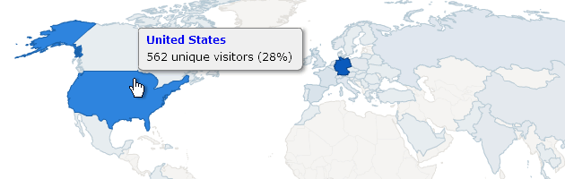
Interactive world map: The plugin provides a new dashboard widget showing an interactive world map. The countries are colored according to the selected data metric (like number of unique visitors). It is possible to zoom into certain regions to get a closer look at smaller countries. While moving the mouse over countries, tooltips show the exact value and its ratio. Piwik API integration: The map is fully integrated into the new Piwik report API, so there is no limitation on the displayed data metrics. Legend: Besides the map there is a small legend that helps to interpret the country colors. This is especially helpful, if you want to print out the map. Fullscreen: You can set the map into fullscreen mode. This is very handy if you’re working on a smaller screen. Image export: It is possible to download the current map view as PNG image, just like the other flash-based charts in Piwik. The exported map view will be resized to 1000px width. You can even export high-resolution images by using the image export while in fullscreen mode (accessible via context menu).
Screenshot
This is how the widget looks, after zooming into Europe: 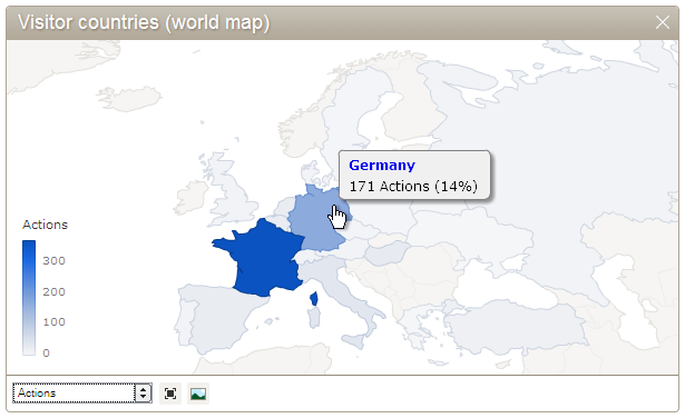 Here is an example for the new fullscreen mode (click image to enlarge):
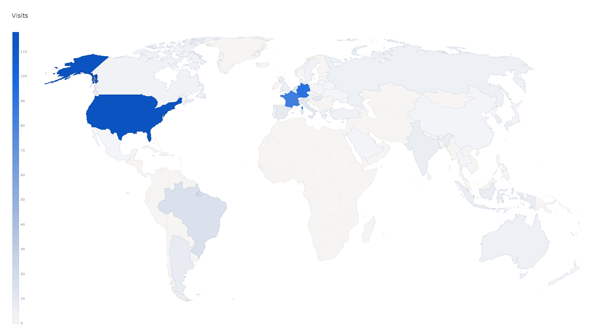
Current progress / Roadmap
Donate
If you like the plugin, please support the developer with a small donation via paypal or flattr. 
Comments
Gregor (Aug 09, 2010)
Thanks for your comment. I already increased the contrast of the inactive countries to make it more readable on different display devices. You’ll find this update in the next piwik release..
Patrick (Jul 29, 2010)
Looks fantastic! You don’t have any idea how grateful I am for your work on this. I’ll donate as soon as I get my next batch of money in… thanks!
Kip (Jul 26, 2010)
Looks great and works very well too. Great job.
Michael Finkenthei (Aug 07, 2010)
Really great jobs, thank you so much for the effort! However, I suppose it would be a good idea to render the borders of the map (at least coastlines) a bit more clearly. Countries without traffic can not even be seen at the moment, which is a bit irritating for some users.
Frederik (Aug 11, 2010)
Hy, dieses Plugin ist ja mal richtig schnieke! :)
Für mich persönlich sehr interessant wäre die “Städte”-Funktion [display vistitors cities as implemented in Google Analytics].
Gibts dazu schon erste Codes zum testen? Man weis ja nicht wie lange GopIP noch benötigt um ins Piwik-Core aufgenommen zu werden. ^^
vlg
Gregor (Aug 11, 2010)
Das GeoIP Plugin bekommt laut Aussage der Piwik-Entwickler nach dem 1.0 Release eine deutlich höhere Priorität und wird dann vermutlich nicht mehr lange brauchen, bis es in den Core wandert. Dann kommt auch die Städte-Visualisierung, genauso wie eine Aufteilung von größeren Ländern wie den USA in einzelne Bundesstaaten..
Frederik (Aug 12, 2010)
Ui, prima! :)
Dann verfolge ich dein Projekt natürlich gerne mit Hochspannung. Wirklich sehr saubere Arbeit! lob
vlg
vis4.net: Visual Interaction Development in Flash, HTML5 and Processing (Aug 27, 2010)
[…] Here are my ideas for the next version of Piwik Maps. […]
Nico (Aug 27, 2010)
this is a great Mao, are you going to implement a feature that will break it down by state and city? so its more acurate? something like google maps!
Why We Need Another Mapping Framework — vis4.net (Jun 03, 2012)
[…] by porting the PROJ.4 library to ActionScript. My first notable interactive map application was a world map widget for the Piwik Analytics project, which is in use until today. It was born from the need to have a […]